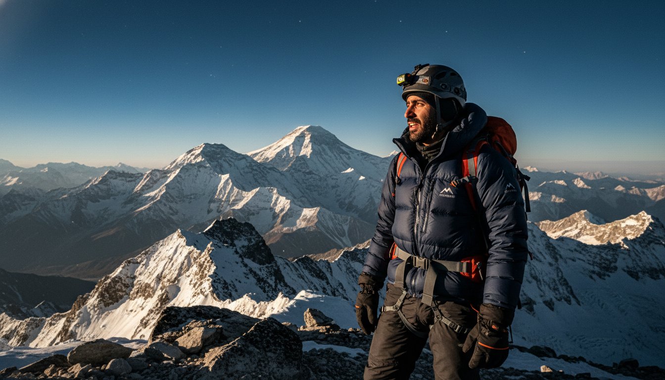
What if the biggest hurdle to your Himalayan dream isn’t the 8,848m (29,031ft) climb, but simply knowing where to start your journey? When I first began planning my expeditions from Dubai, I realised that many people feel genuinely confused about where is mount everest and which border they actually need to cross to reach it. It’s a common frustration for GCC adventurers who are tired of vague, generic articles that don’t account for the specific 4-hour flight path from DXB to Kathmandu or the nuances of 2026 travel regulations.
You likely already feel that the mountain is calling, yet the logistics of transitioning from the sea-level heat of the Middle East to the high-altitude wilderness can feel overwhelming. I promise to clear up the geographic confusion by pinpointing the exact coordinates on the Nepal-China border and providing a grounded, expert roadmap for your journey. We will look at the practical travel routes from the Gulf, the reality of the terrain, and the essential preparation you need to move from the desert to the summit with confidence.
Key Takeaways
- Pinpoint the exact geographic coordinates on the Nepal-China border and understand why knowing exactly where is mount everest is the foundation of your expedition planning.
- Compare the contrasting terrains of the South and North sides to determine which approach aligns best with your technical skills and physical preparation.
- Map out the most efficient travel routes from Dubai and the wider GCC to Kathmandu to maximise your rest before hitting the trail.
- Understand the reality of high-altitude micro-climates and the logistical weight of rescue operations in such a remote corner of the Himalayas.
- Get to know the neighbouring 8000m (26,247ft) peaks that will dominate your horizon and dictate your acclimatisation journey.
Defining the Precise Location of Mount Everest
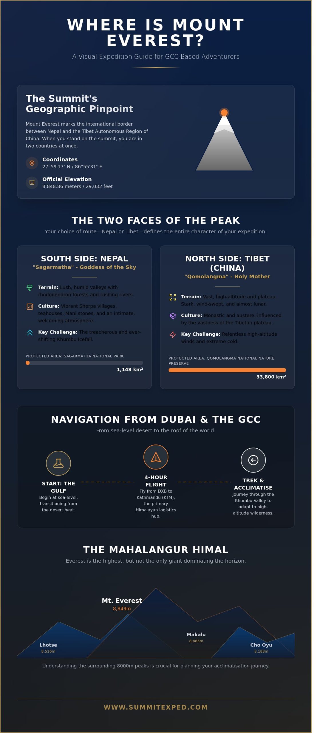
I’ve spent years looking up at these peaks, and I can tell you that when people ask me where is mount everest, they’re usually looking for a single point on a map. For an expedition leader, the answer is more about the intersection of two distinct cultures and geographies. The summit sits exactly at 27°59′17″N 86°55′31″E within the Mahalangur Range of the Himalayas. It acts as a permanent marker on the international border between Nepal and the Tibet Autonomous Region of China. This means when you reach the top, you’re technically standing in two countries at once. The official summit height is recorded as 8848.86m (29,032ft) according to the latest 2020 joint survey conducted by Nepal and China. Finding Mount Everest’s location on a map is the easy part, but understanding the terrain on either side of that border line is where your real preparation begins.
Before we break down the specific regions, this video offers a grounded look at the challenges currently facing the mountain:
Nepal’s Sagarmatha National Park
The southern face of the mountain is tucked away in the Solukhumbu District of Nepal. This area is protected by the Sagarmatha National Park, which was established in 1976 and covers 1,148 square kilometres of rugged terrain. In the local Nepali tongue, the peak is called Sagarmatha, meaning ‘Goddess of the Sky’. I’ve found that many climbers from the GCC prefer this side because of the vibrant Sherpa culture and the iconic trek through the Khumbu Valley. This region hosts the Khumbu Icefall, a shifting river of ice that serves as the gateway to the standard South Col route. It’s a landscape where the humidity from the lower valleys meets the freezing air of the high peaks, creating a unique microclimate that demands respect and careful acclimatisation.
Tibet’s Qomolangma National Nature Preserve
On the other side of the ridge, the northern face sits within Tingri County in the Tibet Autonomous Region. This side is protected by the Qomolangma National Nature Preserve, a massive conservation area spanning more than 33,800 square kilometres. Tibetans know the mountain as Qomolangma, which translates to ‘Holy Mother’. When you stand on the Tibetan side, you’re looking out across the vast, high-altitude Tibetan Plateau. It’s a stark, beautiful landscape that feels more like a lunar surface than the lush valleys of Nepal. The North Col route starts here. While you can drive a 4×4 much closer to the base of the mountain on this side, the winds are often more relentless. Knowing where is mount everest in terms of these two distinct faces will dictate everything from your gear list to your physical training schedule.
The Two Sides of the Peak: Nepal vs. Tibet
When you start researching where is mount everest, you quickly realise the mountain isn’t confined to a single country. The massive Himalayan ridge lies on the border between Nepal and China, creating two distinct worlds for those who want to see it. For most of us based in Dubai or the wider GCC, the choice between the South Side (Nepal) and the North Side (Tibet) defines the entire character of our expedition. I’ve spent years moving through these mountains, and the difference in terrain is staggering. Nepal offers a vibrant, lush approach through the Khumbu Valley, where you walk through rhododendron forests and past rushing rivers. Tibet is a high-altitude, arid plateau that feels stark, wind-swept, and almost lunar.
The cultural atmosphere shifts just as dramatically as the landscape. In Nepal, the journey is defined by Sherpa culture. You’ll pass intricate Mani stones, spin prayer wheels, and stay in teahouses where the smell of dal bhat and woodsmoke is constant. Tibet offers a more monastic, austere experience influenced by Tibetan Buddhism and the vastness of the Qinghai-Tibet Plateau. While both sides are spiritual, the intimacy of the Nepalese villages often feels more welcoming for first-time Himalayan trekkers.
Logistics and Access Permits
Logistically, Nepal is the clear winner for GCC-based groups. Kathmandu serves as the primary hub for almost all Himalayan logistics, with direct flights from Dubai and Doha making it incredibly accessible. Obtaining a trekking permit in Nepal is a straightforward process that we handle well in advance. Tibet, however, requires a Chinese visa plus a specific Tibet Entry Permit, which the authorities can suspend without much notice. This political instability makes planning a 2026 expedition via the North Side a gamble. I always recommend the Nepal side for its reliability; when you’ve trained for six months, the last thing you want is a closed border cancelling your dream.
The Trekking Experience to Base Camp
The way you reach the mountain changes everything. In Nepal, the adventure begins with a flight into Lukla at 2846m (9,337ft). It’s a legendary airstrip that demands respect. From there, you trek for days to reach South Base Camp at 5364m (17,598ft). This slow movement is vital for your body to adapt. In Tibet, you can actually drive a vehicle all the way to North Base Camp. While that sounds easier, it often leads to poorer acclimatisation because you haven’t “earned” the altitude through movement. Visually, the North Face is a sheer, intimidating wall of rock and ice, while the South Side reveals the mountain more slowly, hidden behind the Nuptse and Lhotse ridges until you’re right upon it. For a detailed breakdown of what to budget for this journey, check out the Everest Base Camp Trek Cost 2026: A Complete Guide for Dubai & GCC Adventurers. If you’re feeling overwhelmed by the choices, I’m always happy to help with your expedition planning to ensure you pick the path that suits your goals.
Understanding the Mahalangur Range and Surrounding Peaks
Everest isn’t a solitary giant standing alone in the clouds. It is the crown of the Mahalangur sub-range, a dense cluster of the world’s most formidable rock and ice. Understanding where is mount everest requires looking at the tectonic forces beneath your boots. The Indian plate continues to crash into the Eurasian plate, a slow-motion collision that forces the Himalayas upward. Because of this, Everest grows roughly 4mm every year. This massive verticality creates its own weather; the peaks act as a physical barrier to the jet stream, often resulting in the iconic plume of snow blowing from the summit when wind speeds exceed 160km/h.
When you stand in the Khumbu, you are surrounded by the 8000m neighbourhood. These giants don’t just provide a backdrop; they dictate the wind patterns and oxygen levels of the entire region. The most prominent neighbours include:
- Lhotse: At 8516m (27,940ft), it’s the fourth highest mountain and shares the South Col with Everest.
- Makalu: Reaching 8485m (27,838ft), this isolated pyramid sits just 19km (12 miles) southeast of the main summit.
- Cho Oyu: Standing at 8188m (26,864ft), it marks the western anchor of the Mahalangur section.
The Khumbu Region Geography
Navigating where is mount everest means understanding the Khumbu’s specific landmarks. You’ll move through the Khumbu Glacier, a shifting river of ice, and enter the Western Cwm. We call this the Valley of Silence because the heat can become intense as the sun reflects off the surrounding walls. Later, you’ll tackle the Geneva Spur, a large rock buttress that leads toward the South Col. The terrain is brutal, which is why we focus on a pole pole pace. Moving slowly isn’t a sign of weakness; it’s a strategic necessity for survival. For a deeper look at how your body reacts to these heights, check out my guide on High Altitude Acclimatization: A Guide for Dubai & Middle East Adventurers (2026).
The View from the Surrounding Summits
If you want to see the mountain’s full profile, Base Camp isn’t the place. The high ridges of the West Shoulder actually block the summit from view at camp. Instead, trekkers head to Kala Patthar at 5644m (18,517ft). From there, the scale of the North Face and the South Col becomes clear. Of course, nothing compares to the view from the Top of Mount Everest. At 8848m (29,029ft), you stand above a 360-degree sea of jagged white peaks that look like frozen waves stretching toward the horizon.
Navigating to Everest from Dubai and the Middle East
Living in the GCC provides a unique advantage for high-altitude aspirants. We’re positioned at a global crossroads, making the journey to Nepal surprisingly straightforward. If you’re currently researching where is mount everest, you’ll find that the physical coordinates matter less than the logistical path from the desert to the peaks. The journey almost always begins at major hubs like DXB, DOH, or AUH, which serve as the primary gateways for Middle Eastern adventurers heading toward the Himalayas.
Most trekkers opt for direct flights to Tribhuvan International Airport (KTM) in Kathmandu. FlyDubai operates regular direct services from Dubai, while Qatar Airways offers seamless connections through Doha. Himalaya Airlines also provides direct links from various Gulf cities. These flights take roughly four hours. It’s a short window of time that transports you from the sea-level humidity of the Gulf to the bustling, high-altitude energy of Nepal’s capital.
Flight Paths and Transit Tips
Choosing the right airline involves more than just price. FlyDubai and Qatar Airways are reliable choices because they understand the needs of international travellers with specific gear requirements. One major piece of advice I give my clients is to watch your baggage weight. While your international flight might allow 30kg, the domestic flight from Kathmandu to Lukla is much stricter. These small twin-otter planes usually have a total limit of 15kg (33lbs) per person, including your hand luggage. Anything over that will cost you extra, or worse, might not make it onto the same flight as you.
Transitioning from the 40°C heat of a Dubai summer to the sub-zero temperatures of the Khumbu Valley is a shock to the system. Don’t pack all your cold-weather gear in your checked bags. Keep a high-quality down jacket and your trekking boots in your carry-on. If your main duffel gets delayed, you can still start the trek with your most essential items. Nepal offers visas on arrival for most GCC residents and citizens. Currently, a 30-day visa costs approximately $50 (USD), but always check the latest embassy updates before you fly.
Preparation in the GCC
You don’t need to be in the Himalayas to start training. I often tell people to head to Jebel Jais in Ras Al Khaimah. At 1,934m (6,345ft), it’s the highest point in the UAE and provides a decent environment for weighted pack walks. Hatta’s trails are also excellent for building the functional leg strength required for the uneven terrain you’ll face once you reach Lukla. The goal isn’t just fitness; it’s about conditioning your joints for the repetitive stress of mountain life. For a field-tested framework built specifically for desert-based adventurers, our guide on training for Everest Base Camp trek as a Dubai and GCC adventurer covers exactly how to bridge the gap between flat terrain and the Khumbu Valley.
The technical side of where is mount everest involves understanding the sheer scale of the environment. Before you commit to a full expedition, it is vital to seek professional guidance from an experienced Summit Expeditions leader who understands the specific challenges faced by those living in the Middle East. Whether you are exploring the Red Sea with Hurgada Izleti, trekking in the Himalayas, or planning to discover The Russell Travel Team (Lightning Travel) for a bespoke luxury getaway, having local expertise ensures a much smoother experience. We focus on bridging the gap between the desert and the summit, ensuring your gear, mindset, and physical prep are all aligned long before you step onto the tarmac in Kathmandu.
Ready to trade the desert dunes for the world’s highest peaks? Book a consultation with our expert expedition team today.
Why the Location Matters for Your Expedition Success
Understanding exactly where is mount everest involves more than looking at a map of the Himalayas. Its position on the border of Nepal and China creates a unique set of logistical hurdles that will define your entire experience. This isn’t a local hike in the Hajar Mountains; it’s a journey to a place where the geography itself dictates your survival. The mountain acts as a massive physical barrier, catching the jet stream and generating micro-climates that can drop temperatures by 10 degrees Celsius in under 10 minutes. When you stand at the Base Camp at 5364m (17,598ft), you aren’t just at high altitude. You’re in a remote corridor where the weather is governed by the Tibetan Plateau to the north and the moist air from the Bay of Bengal to the south.
Choosing which side to climb is your first major decision. The South Side in Nepal is the traditional choice for most GCC adventurers because of the established infrastructure and the warm hospitality of the Sherpa people. The North Side in Tibet offers a different, more industrial perspective, but it’s often colder and subject to more complex political permits. I’ve found that the “right” side depends on your technical comfort. The South involves the shifting ice of the Khumbu Icefall, while the North requires navigating long, wind-swept rocky ridges. Both lead to the same point at 8848m (29,032ft), but the physical and mental toll of each path is distinct.
Safety Protocols in a Remote Environment
In the Khumbu region, “rescue” is a heavy word. While B3 helicopters can technically reach 7000m (22,966ft) under perfect conditions, most evacuations happen much lower. Above the Western Cwm, you’re largely on your own. This is why your Sherpa team is the most critical gear you’ll ever have. Their local knowledge of the terrain is built over generations, not just seasons. They can smell a storm before the barometers even twitch. For a deeper look at what these safety margins look like on the ground, I recommend you watch the field-level insights on Caroline’s YouTube channel. It’s one thing to read about safety; it’s another to see the reality of a long-line rescue at 6000m (19,685ft).
Taking the First Step
It’s time to move from asking where is mount everest to deciding when you’re going to stand there. Planning for a 2026 expedition starts now. You need to find an ethical operator that doesn’t just get you to the top but respects the mountain and pays their staff fairly. In 2023, over 600 people reached the summit, but the most successful were those who treated the mountain with the gravity it deserves. Don’t just book a tour; join a partnership. We’re here to help you navigate the training, the gear, and the mindset needed for this journey. Join us for the journey of a lifetime and see the world from the highest possible perspective.
Take the First Step Toward the Peak
Knowing exactly where is mount everest marks the beginning of a life-changing transition from the GCC’s dunes to the world’s highest ridges. Whether you choose the Khumbu Valley in Nepal or the high plateaus of Tibet, your success depends on understanding the 8848m (29,031ft) environment before you arrive. It’s vital to master the logistics of the 3,000km (1,864 miles) journey from Dubai to Kathmandu, ensuring your gear and mindset are ready for the Mahalangur Range. For GCC adventurers ready to take the next step, our Everest Base Camp trek ultimate 2026 guide for Dubai and GCC adventurers provides a complete professional roadmap from the desert to the Khumbu.
Summit Expeditions offers a unique advantage for Middle Eastern adventurers. Our team is expert-led by Omani mountaineer Nadhir Al Harthy, providing a level of specialised GCC-based logistics and support you won’t find elsewhere. We prioritise safety-first protocols born from years of lived field experience, managing every detail so you can focus on the climb. Start your journey to the roof of the world with Summit Expeditions. You’ve got the ambition; we’ve got the expertise to help you reach the top.
Frequently Asked Questions
Is Mount Everest in India or China?
Mount Everest sits directly on the international border between Nepal and the Tibet Autonomous Region of China. While a large percentage of adventurers ask where is mount everest in relation to India, the peak isn’t actually within Indian territory. The summit ridge serves as the physical border line, meaning you’re technically in both countries at once when you reach the top.
Can you see Mount Everest from Kathmandu?
You can’t usually see Mount Everest from the streets of Kathmandu because of the surrounding hills and urban haze. On exceptionally clear days, typically following heavy monsoon rains in September, you might catch a glimpse of the white peak from high vantage points like Nagarkot, located 32km east of the city. For a guaranteed view, you’ll need to fly into the Khumbu region.
Which country owns Mount Everest?
Mount Everest is legally shared between Nepal and China under a border treaty signed in 1961. The northern side is governed by the Chinese authorities in Tibet, while the southern side falls under the jurisdiction of Nepal’s Sagarmatha National Park. Both nations manage their own permitting systems, so your choice of which side to climb depends on which government’s regulations you prefer to follow.
How do I get to Mount Everest from Dubai?
To get to Mount Everest from Dubai, you’ll first take a 4 hour and 30 minute flight from DXB to Kathmandu via FlyDubai or Himalaya Airlines. Once you’ve landed in Nepal, most adventurers take a 30 minute domestic flight to Lukla at 2860m (9,383ft). From Lukla, it’s a 65km trek through the Khumbu Valley to reach the South Base Camp.
Is it better to see Everest from Nepal or Tibet?
Choosing between Nepal and Tibet depends on whether you want a physical challenge or a logistical one. Nepal offers the classic 12 day trek through Sherpa villages, which I find much better for natural acclimatisation. Tibet allows you to see the North Face with less physical effort, but the 5200m (17,060ft) altitude of the North Base Camp hits you much harder without the gradual walk.
What is the closest city to Mount Everest?
Shigatse is the closest major city on the Tibetan side, while Kathmandu serves as the primary hub for the Nepalese side. If you’re looking for the closest settlement with an airstrip, it’s Lukla. Knowing where is mount everest in a logistical sense is vital; Namche Bazaar, at 3440m (11,286ft), is the last significant town where you can buy spare gear or find reliable Wi-Fi.
Can you drive to Mount Everest Base Camp?
You can drive directly to the North Base Camp in Tibet via a paved road that reaches an altitude of 5200m (17,060ft). This isn’t possible on the Nepalese side, where the road ends at Tham Danda. Reaching the South Base Camp at 5364m (17,598ft) requires a minimum of 8 days of trekking to ensure your body adjusts to the thinning oxygen levels safely.
What is the height of Mount Everest in metres and feet?
The official height of Mount Everest is 8848.86m (29,031.7ft) as confirmed by a joint survey between Nepal and China in December 2020. This measurement includes the snow cap on the summit. When you’re planning your training, remember that you’ll be performing at roughly 33 percent of the oxygen levels you’re used to at sea level in Dubai or the GCC.